Showing posts with label Scrambling. Show all posts

Friday, July 15, 2011

Ha Ling - A Canmore Classic

July is always a good month to revist an old favourite of mine and a favourite of many Calgarians.  Ha Ling rises over 900m above Canmore Alberta, but despite its imposing cliffs, it is a very popular peak that can see over 100 people summit on a warm day.

Nearly 4 months after my last mountain adventure, I decided to take a break from paddling and test out my mountain legs.  Along with four friends we started our way to Canmore to tackle this imposing wall of rock...

The adventure continues by clicking here...

Thursday, January 6, 2011

Mt. Kosciuszko - The Highest Point In Australia

Boy, its taken a long time to write this. Between training for the South Dakota Kayak Challenge and planning/researching a Mt. Kilimanjaro/Mt. Meru expedition I really haven't had much time to do this.

Its sad since Kosciuszko does hold he title of tallest Mountain in Australia, its also part of the Bass List of Seven Summits (the highest mountains on each continent). At 2228m (7,310ft) it is the smallest mountain on the list - which also includes: Mt. Everest (Asia), Mt. Aconcagua (South America), Denali (North America), Mt. Kilimanjaro (Africa), Elbrus (Europe) and lastly Vinson Massif (Antarctica).

Its argued that Kosciuszko (Kosi as the locals call it, Tar Gan Gil to the Aborigines) does not belong on that list and that Carstensz Pyramid in Indonesia is the tallest mountain on the Australia/Oceania continent, standing at 4,884m (16,023ft). This debate has led to two Seven Summit lists, the Bass List and the Messner List. The only difference between them is the Kosi - Carstensz switch. But alas, this is not about that debate or winning anybody over, its about the beauty and experience I had journeying to the roof of Australia and my first Southern Hemisphere summit.

My goal at the end of 2010 was to have climbed/scrambled/hiked/etc to the summit of 30 different mountains, as winter came I knew I would be hard pressed to make it. On December 29th - over 14,000km from home, Mt. Kosciuszko became number 30.

During the afternoon of December 28th, my wife Deb and brother-in-law George packed our car with camping gear and headed out to Jindabyne NSW, we arrived at our campsite just after midnight on the 29th, and decided to promptly go to bed. The next day we got up and decided for the ease of first-time hikers that we would ascend via Charlotte's Pass, a modest total elevation gain of about 400m, but a horizontal distance of about 17km round trip. We started out on the trail at about noon. Before long the parking lot was well behind us and we were hiking our way through the Great Dividing Range. The first thing that I noticed was still patches of snow - this was afterall in December, the middle of the southern hemisphere's summer. Even at an elevation of about 2000m (7000ft), I had expected the snow to have sublimated away at the very least under the power of the Australian sun. Not that I was complaining, I am actually happy there was snow. The next thing I immediately noticed, was the lack of large dominating craggy spires and peaks. It was a very nice change from the peaks of Alberta, it provided a very exotic feel, especially with the gum trees. I kept an eye in the valley for the chance to see a wallaby, kangaroo or emu, but alas, I believe the preceding cold weather had driven them to lower altitudes

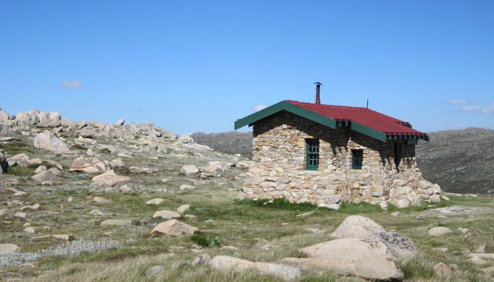
Another bonus of this route (which is the most popular) was the fact that after about 4.5 kilometres, we had the pleasure of passing another Australian Icon - the Snowy River. This is the same river made famous by Banjo Patterson back in 1890 and then renewed its fame with a 1982 movie starring Kirk Douglas. The Snowy River has its origin a mere 4km from the the trail and is fed by melt water from the snows. After watching the tiny fish swim around, posing for a few photo ops and dipping my foot into the waters, we continued on our way to Seaman's Hut (a winter refuge for back country enthusiasts) at 2030m. The hut is also a stark reminder that even a relatively small innocuous mountain can turn deadly. In 1928, W. Laurie Seaman and Evan Hayes died in a winter storm while. The Seaman family built the shelter for future park users to prevent another such tragedy. Sadly over the years, people have still fallen victim to avalanches and winter storms.

When we all reached Seaman's Hut, we knew we were within 4 km of the summit. I must admit I was getting excited and just couldn't get bored of the scenery. The trail made a long twist around a rocky outcrop and more of the Australian Alps that were hiding became visible. A high peak came into view, with its rocky top, I pegged it (correctly I later found out) to be Mt. Townsend, the second highest peak in Australia (a mere 19m shorter than its sister). From previous research I knew this to be only 3.8km from the summit of Kosciuszko. Along the walk I put out a feeler to Deb and George if any of them wanted to do a quick side-trip to Mt. Townsend and bag the second highest moutain in Australia. That suggestion was met with a duel no. I mentioned the traverse would be short, and elevation loss minimal. Again, double no. I even tried the patriotic card, telling them that they could be one of the few to stand on the two highest peaks in their country. That seemed to have little effect, so I gave up. But not before I put it in my mind (and mentioned it in passing) that next time we come to Australia, I will be spending a few days camping and bagging some of the other mountains in the area. Shortly after a party descending passed us and we asked where the summit of Kosi was. They told us that in a few minutes the trail would bank a hard left and we would see it right in front of us. In fact the mountain we were looking at straight-on was the south-eastern slope of our intended destination - the summit was just blocked by the hill beside us. Sure enough, within a few minutes, the summit came into view - I can't say it was awe-inspiring or a take-your-breath away moment but it wasn't disappointing either. It was little more than a rounded knob with a few patches of snow, but breathtaking in its own right. What none of us really realised at that time, was that Kosciuszko was holding a present for us, only to be shown to those that summit.

Before we made the final summit approach, the trail leads you to Rawson Pass (2100m), home of Australia's highest toilets built in 2007. Cleaned daily they see approximately 100,000 "visitors" a year. Just a nice bit of trivia really.

From Rawson's Pass the trail climbed the final 122m along the south-eastern face of Kosciuszko before starting a one-loop spiral that would circumnavigate the entire summit before ending at the Survey Cairn that marked the highest point in Australia. In my opinion this is where the scenery changed from great to excellent (as with the vast majority of summits). Now higher than most of the surrounding peaks, the scale of the Great Dividing Range became apparent, until this point, we were hiking through a valley, slowly gaining elevation, our views limited by the mountains on either side of us. Now, free of the valle confines we were able to peer into the far distances. We were able to see the various walls of mountains undulating into the horizon, stopping only where they ran against the clouds of the sky.

Before long, were came around the final corner and the summit cairn was in view. After about 4 hours and 8.5km of hiking we had reached the Roof of Australia. After taking our obligatory photos with the summit cairn, we sat down and enjoyed the great weather, scenery and natural beauty of the area before heading back to Charlotte's Pass.


Sunday, October 31, 2010

Rimwall Summit - 2010/11 Winter Scrambling Is Officially Here!

Rimwall Summit is a moderately rated scramble that has an elevation gain of 1020m/3,346ft and a summit elevation od 2680m/8,792ft. It has been on my to-do list for a while and with summer quickly slipping away and winter taking its chilly frozen hold on the Rockies, there was no better time than now to do it.

With three friends, we left Calgary at 5:00am with dreams of a clear pre-sunrise approach followed by an alpine sunrise giving way to clear blue skies and a high of 3C, afterall, this is pretty much what the forecast told us - we should have also realised that the closer you get to the mountains, the less you can trust the forecast. We knew it would be chilly when we first arrived at the trail head, and chilly it was (cold is in a different class than chilly - as you will shortly find out). The lack of clouds caused the mercury to drop a bit more and as we exited our warm cozy vehicle, we were welcomed with an brisk ambient air temperature of about -9C. Let this be a lesson, never keep a car very warm when you are to go winter scrambling or hiking, slowly lower the internal temperature so its not such a shock to the system when you get out (we knew better).

We started our approach under a half-moon with the constellations shining brightly above us - Orion and Cassiopeia being the main stellar attractions. The first part of the approach was through forest on a nice trail, but having to keep with tradition, Siva and I decided that off-trailing would be (as we normally do) the way to go, so off trail we went scrambling some rockbands and doing some minor bushwacking until we finally came to the treeline. From the treeline we knew we had to continue up, but this is where things started getting interesting. We were provided a nice sunrise off of Mt. Lougheed as its snow dusted and cloud enshrouded summit burned red under the rising sun, but the clouds wouldn't stop rolling in, and soon enough visibility was reduced to about 10m in any direction. The wind was blowing at what we estimated was 60-70kph, snow crystals became eye-stinging ballistics, and the temperature quickly plummeted to below -20C, even our insulated drinking tubes couldn't withstand the coldness and succumbed to freezing solid.

Without this temperature and conditions, I don't know how eventful the summit trip would be, but add blustery winds, low temperatures and a bit of snow and ice and you get some good stories to tell - like how we only really knew the general direction to go and where the general location of the big cliff was. Suffice it to say we continued on to the summit, scrambled over the snowy, icy cliff bands shoved a big stick in the summit cairn where we took a few pictures and then headed down after a poor attempt to find the summit register. The funiest thing happened about 35 minutes of leaving the summit. The wind stopped, the angels sang and the clouds parted to reveal a beautiful clear autumn day overlooking Spray Lake the the entire length of the valley.

We did see another group of 6 people heading for the summit as we descended and knew they would now have a great trail to follow and have a great clear summit experience. Our experience was great though, the addition of bad conditions makes the ascent more interesting and adds a new degree of difficulty, at the very least, we didn't have to peer down on Canmore one more time from the summit and the windburn on our face will subside. 5 hours and 55 minutes after leaving the car, we were again standing on the side of the road putting our gear in the trunk and getting ready to go to Canmore for some hot chocolate.

On a sad note, as I did check "Rimwall Summit" from my list, I had to add "new camera" to it, as it succumbed finally to the orgy of rocks, cold, snow, trees, bumps, scrapes, drops and wet that the mountains had thrown at it over the past 2 years. Here is the last video that my camera would take (listen to the wind).