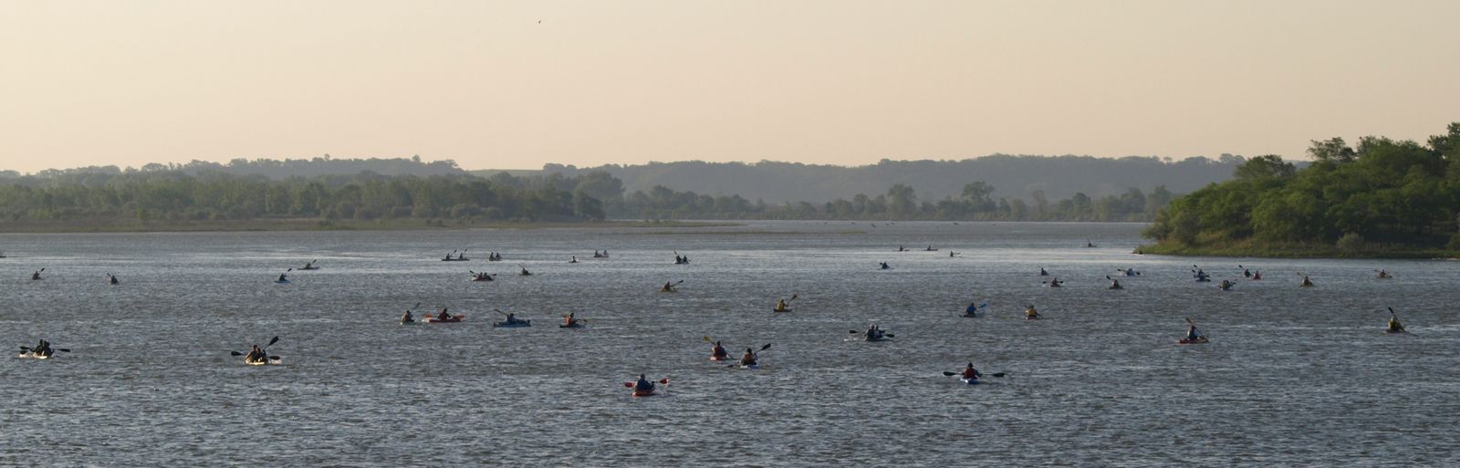
This weekend will mark the 2 month countdown to the Second Annual South Dakota Kayak Challenge. A challenge primarily and a race secondary, that will see about 100 racers line the shore of Riverside Park in Yankton SD and with the sound of a gun, start their journey along a 75 mile (120km) section of the mighty and historic Missouri River, crossing into three states and finally finishing in Sioux City Iowa. As such, I have dedicated this entry to the challenge in an attempt to answer many questions for people that I have talked to that are interested in taking part in this great event.
THE COURSE
As stated, the course is approximately 75 miles (121km) in length, for which each boat will have 30 hours from the starting gun to finish. This 30 hours includes all breaks, naps and calls-of-natures there may be.
The course has 4 check points, Myron Grove, Mulberry Bend, Bolton and Rosenbaum which can divide the race into 5 spearate legs. Below are descriptions of the race based on my experiences last year and from talking ot the organizers and other fellow competitors.
LEG 1

The first leg between Riverside Park and Myron grove is a 17.5 mile (28km) downstream stretch of river that is channeled by numerous large islands and many more smaller islands, however, the flow is relatively unimpeded and the water deep. Last year there were a few sandbars along this route, but nothing major. The only real concern that I would say there is in this leg is a branch in the river after about 5 miles (8km), a smaller branch will flow north while a second brach flows south. I advise all would be paddlers to take the southern branch as its the more direct route and the northern route will lead you through what appeared to be a narrow, shallow channel that has its fair share of small islands you'd have to negotiate around before rejoining the main channel - it also adds about 0.6mi (1km) to your overall distance. I didn't hear about anyone taking the northern route last year - probably because you can still follow the crowd of paddlers, but it wouldn't be hard for a person to take it.
LEG 2
The second leg of the race between Myron Grove and Mulberry Bend is 11.5 miles (18.5km) in length. About 0.5mi (0.8km) after the Myron Grove checkpoint, the river becomes divided by Goat island, an island about 4.5 miles (7.2km) long, forcing you to choose one of two channels - a northern channel and a southern channel. Last year we we pulled into Myron Grove in a group of about 5 boats all within 7-10 minutes of each
 other. Of those boats, Tyler and I were the only boat to take the south channel. In retrospect, I would still recommend paddlers to take the southern channel. From accounts from volunteers and other racers, the northern channel is more channelized as it is divided even further by smaller islands. When the two channels merged, we had actually made time and distance on a few boats that left Myron Grove before us and even passed one or two. About 0.8miles (1.3km) the Missouri River will start to have fun with you - the river flows around two islands creating 3 channels and water levels drop. Last year the southern channel had many downed trees and some sandbars that were visible. We opted for the middle channel which for the most part was decent, however we pulled too close to the first island and quickly found ourselves bottoming out - coming to a complete stop in the middle of the Missouri River. As we quickly found out, the middle channel has a large barely submerged sandbar that sticks out about a quarter of a mile from the north shore of the island. In retrospect, we should have hugged closer to the southern shore of the second island as I believe the water was deeper. After these islands the river takes a sharp turn to the south where these sandbars are pretty much part of the scenery for the last 5 miles (8km) before Mulberry Bend. It is also around this time the headwind wind really started to pick up (20-30mph, 30-50kph).
The third leg of the race is about 12 miles (19km) from Mulberry Bend to the Bolton checkpoint. I stongly remember a st rong channelized current along this section, one that is not hard to miss and if you can ride it, can propel you through the bend in quite a short amount of time - I do also remember som very large boils that threaten to derail your run if you happen to slip out of this current. Just over 3 miles (5km) after Mulberry Bend, the river will fork into three channels. I remember the south channel being filled with shallows and sandbars, the same with the middle channel, however, if you stay river left in the middle channel you should miss the shallows and the sandbars. From the sounds of it, the northern channel is completely clear of sandbars and might be worth attempting this route as the length difference is less than 0.2mi (0.3km) and might mitigate the decrease in speed caused by the sandbars and shallows. Immediately after the shallows two large sandbars are present and highly viible in the middle of the river - avoid them - though if you need a break, I did see one boat pulling over on them. The river channel will then squeeze past a peninsula before flowing around a small treed island - I'd again recommend river right around this island until the Bolton checkpoint.
LEG 4
 rong channelized current along this section, one that is not hard to miss and if you can ride it, can propel you through the bend in quite a short amount of time - I do also remember som very large boils that threaten to derail your run if you happen to slip out of this current. Just over 3 miles (5km) after Mulberry Bend, the river will fork into three channels. I remember the south channel being filled with shallows and sandbars, the same with the middle channel, however, if you stay river left in the middle channel you should miss the shallows and the sandbars. From the sounds of it, the northern channel is completely clear of sandbars and might be worth attempting this route as the length difference is less than 0.2mi (0.3km) and might mitigate the decrease in speed caused by the sandbars and shallows. Immediately after the shallows two large sandbars are present and highly viible in the middle of the river - avoid them - though if you need a break, I did see one boat pulling over on them. The river channel will then squeeze past a peninsula before flowing around a small treed island - I'd again recommend river right around this island until the Bolton checkpoint.
LEG 4
Bolton checkpoint to Rosebaum comprises the fourth leg of the race. This 14.5 mile (23.3km) section sees the river gradually taper into a more narrow even banked single channel river. About 1.5 miles (2.5km) after the Bolton checkpoint wingdykes begin to appear on the right bank. These are worth crossing the river for. Wingdykes are fabulous inventions, built by the US Army Corps of Engineers, they  are rock structed that are built out into the river perpendicular to flow and they force water away from the shore, narrowing the river and creating quick channelized currents as water flows around them. Be warned, they also produce extremely large boils behind the structure, but behind them the water is calm and is a good place to rest if you need to. Be careful about not hitting one though as the force of the watter hitting it can pin and/or capsize a boat - this is more important at night or in low visibilty conditions, normally they are easy to avoid. I have heard stories of this happening (not in the SDKC though). If you are a confident paddler these currents can really be beneficial. The first set of wingdykes will last for about 0.8 miles (1.3km) - enough to let you know if you want to use them. By staying river right you will avoide major channelization and shallower water on the opposite bank as the river turns southwards towards Rosenbaum. The rest of the leg except for the 2.3 miles (3.8km) before Rosenbaum is fairly straight forward paddling with no obstacles. Near the end of this leg wingdykes will again appear, this time on the left shore before stopping and picking up on the right shore. Good paddlers in good conditions iwll be able to skirt across the river and use these to their benefit, at the same time, this is were recreational motor boat traffic will wreak havoc the most - and it will only get worse.
LEG 5
 are rock structed that are built out into the river perpendicular to flow and they force water away from the shore, narrowing the river and creating quick channelized currents as water flows around them. Be warned, they also produce extremely large boils behind the structure, but behind them the water is calm and is a good place to rest if you need to. Be careful about not hitting one though as the force of the watter hitting it can pin and/or capsize a boat - this is more important at night or in low visibilty conditions, normally they are easy to avoid. I have heard stories of this happening (not in the SDKC though). If you are a confident paddler these currents can really be beneficial. The first set of wingdykes will last for about 0.8 miles (1.3km) - enough to let you know if you want to use them. By staying river right you will avoide major channelization and shallower water on the opposite bank as the river turns southwards towards Rosenbaum. The rest of the leg except for the 2.3 miles (3.8km) before Rosenbaum is fairly straight forward paddling with no obstacles. Near the end of this leg wingdykes will again appear, this time on the left shore before stopping and picking up on the right shore. Good paddlers in good conditions iwll be able to skirt across the river and use these to their benefit, at the same time, this is were recreational motor boat traffic will wreak havoc the most - and it will only get worse.
LEG 5
Once you hit Rosenbaum you are 16 miles (25.7km) from the finish line in Sioux City and in the last leg of the race. Technically speaking, this is probably the easiest section of the race, however you have just paddled over 55 miles (88km) through shallows, strong headwind s and around islands and sandbars. From this point on, wing dykes will line the shores of the river (they will be on the outside of every major bend), so confident paddlers will find this helps a lot if they can ride the current. If conditions exist it could be worth skirting the river and riding the wingdykes, I know several paddlers did this. However, the recreational boaters might make this almost impossible. Last year the biggest complaint (after the headwinds) were the boaters throwing huge wakes at the racers - many not really caring and several doing it on purpose. Be very careful around the boaters you can see them, they may not be able to see you. About 11.5 miles (28.5km) after leaving Rosenbaum you will be able to see some extremely large mansions on the left bank, at this point you will probably be riding the wingdykes on that side as well (or avoiding them like the plague) and possibly flipping off some motor boaters, but take pleasure in seeing these, you're less than 5 miles (8km) from the finish and on the second last set of wingdykes. A mere 3 miles (5km) futher you will come to the confluence of the Missouri River and Sioux River on the left shore, but at this point you will probably be fixated on the Sioux City Bridge (Veteran's Bridge). From here make sure you get to the left shore and follow it to Bev's, turn sharply into the marina and bask in the knowledge that you just finished the South Dakota Kayak Challenge.
LESSONS LEARNED FROM 2010
 s and around islands and sandbars. From this point on, wing dykes will line the shores of the river (they will be on the outside of every major bend), so confident paddlers will find this helps a lot if they can ride the current. If conditions exist it could be worth skirting the river and riding the wingdykes, I know several paddlers did this. However, the recreational boaters might make this almost impossible. Last year the biggest complaint (after the headwinds) were the boaters throwing huge wakes at the racers - many not really caring and several doing it on purpose. Be very careful around the boaters you can see them, they may not be able to see you. About 11.5 miles (28.5km) after leaving Rosenbaum you will be able to see some extremely large mansions on the left bank, at this point you will probably be riding the wingdykes on that side as well (or avoiding them like the plague) and possibly flipping off some motor boaters, but take pleasure in seeing these, you're less than 5 miles (8km) from the finish and on the second last set of wingdykes. A mere 3 miles (5km) futher you will come to the confluence of the Missouri River and Sioux River on the left shore, but at this point you will probably be fixated on the Sioux City Bridge (Veteran's Bridge). From here make sure you get to the left shore and follow it to Bev's, turn sharply into the marina and bask in the knowledge that you just finished the South Dakota Kayak Challenge.
LESSONS LEARNED FROM 2010
When most people hear "75 miles (120km)" and "30 hours","paddling" in the same sentence, it usually summons visions of herculean trapezius muscles and biceps or just an impossible combination - this is not the case. This is not an impossible task, 75 miles (121km) in 30 hours is doable if you put your mind to it and practice, all you have to do is believe in yourself and know what you want. There are three kinds of people that will enter this race in my opinion, (1) ones that want to compete to win, (2) those that want to challenge themselves and finish, (3) those that want to just paddle regardless of the outcome. Its easy to know which one you fall into, just believe in yourself and train for that division.
For those people coming this year, the biggest thing that I can pass on is don't let the wind, recreational traffic or other hardships get you down. If you really want to finish but are finding the wind and traffic too much and are thinking of pulling out, get to the shore or into one of the checkpoints. Get ot of your boat and take a breather and a break and talk to other paddlers, they're likely having the same experience as you. A brief timeout or conversation can do wonders and get your mind and body back into the game. If you do decide to pull-out before the finish, don't be hard on yourself, just do it safely. There is always another year and lessons to be learned from past experiences, after all, no competitor in the race would hold it against you or think you lesser or doing so. Ultimately this was set up to be a challenge which by definition is something that summons special skill and strength (both physical and mental) to complete.
If you have competed in the SDKC or plan too, feel free to leave comments or questions below.
For those people coming this year, the biggest thing that I can pass on is don't let the wind, recreational traffic or other hardships get you down. If you really want to finish but are finding the wind and traffic too much and are thinking of pulling out, get to the shore or into one of the checkpoints. Get ot of your boat and take a breather and a break and talk to other paddlers, they're likely having the same experience as you. A brief timeout or conversation can do wonders and get your mind and body back into the game. If you do decide to pull-out before the finish, don't be hard on yourself, just do it safely. There is always another year and lessons to be learned from past experiences, after all, no competitor in the race would hold it against you or think you lesser or doing so. Ultimately this was set up to be a challenge which by definition is something that summons special skill and strength (both physical and mental) to complete.
If you have competed in the SDKC or plan too, feel free to leave comments or questions below.

 On May 29th over 100 paddlers descended upon Yankton , a small city in southern South Dakota, bringing with them 77 canoes and kayaks of various size and style. The people were there for the inaugural